Sunday, May 12, 2013

Divergent Boundary (Placemark #4)

http://www.crystalinks.com/midatlanticridgenoaa.jpg
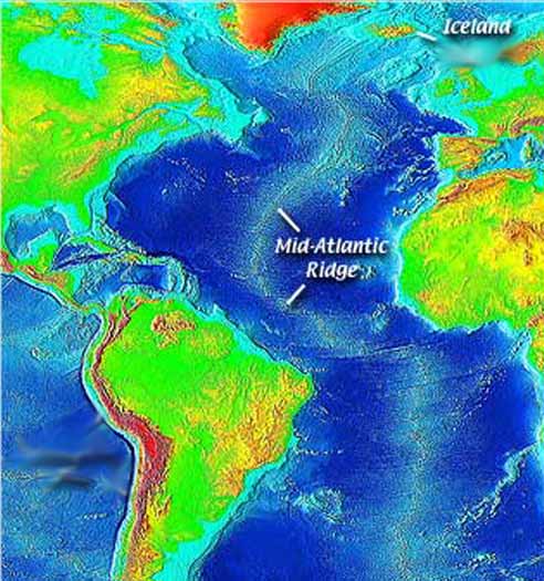
All good things must end, and our tour is coming to a close! But there is still one stop left, and we're heading to the middle of the Atlantic Ocean and Ascension Island! Ascension Island is around 60 miles from the Mid-Atlantic Ridge, in between South America and Africa, and is located at 7°56'24.21"S 14°20'59.91"W. These divergent boundaries is a boundary between two plates that are spreading apart. Most divergent boundaries lie along the ocean floor, and contain rift valleys, which are deep valleys in the middle of a mid-ocean ridge. Below a rift valley, molten rock is forced upwards through cracks/rifts along the valley. When the molten rock cools, it hardens into new oceanic crust. The older oceanic crust on both sides of the rift valley moves away from ridge. This process is sometimes called sea-floor spreading. Rift valleys are typically broken into segments that are separated by fracture zones. These fracture zones run perpendicular to the mid-ocean ridge, and have been found to be a source of the earthquake activity occurring along mid-ocean ridges. If you look at a map that observes elevation, earthquake activity, volcanic activity, and the age of rocks, you should be able to notice that new rocks, earthquake activity, volcanic activity, and shallow elevation all line up. Coincidence? I think not!
That concludes this final blog post and I hope you have enjoyed this once in a lifetime tectonic plate tour!

-KY
http://www.gweaver.net/techhigh/projects/period1_2/Yellowstone/Images/Divergent%20Boundary.jpg
http://go2add.com/images/Volcanoes/DivergentBoundary.jpg

Saturday, May 11, 2013

Transform Boundary (Placemark #3)


http://www.sanandreasfault.org/4020_A.jpg
After traveling to Tibet, I bet you guys are all extremely tired by now. That's why we're going back to the San Francisco to rest up a bit before we go to another exotic location. Of course, this doesn't mean that we can't visit and learn about another type of plate boundary. Near San Francisco is the San Andreas Fault, created by the Pacific Plate and the North American Plate sliding against each other. These types of boundaries are called transform boundaries. The only characteristic they have is that they create many earthquakes, so no volcanoes or large continental mountain chains. The San Andreas Fault line is roughly 810 mi long and runs along the coast of California. The place we're going to visit, the Golden Gate Bridge, is pretty close to the fault and is located near San Francisco at 37°48'29.14"N 122°28'35.96"W. Like at most other boundaries, earthquakes activity is quite common, and because the San Andreas Fault is quite close to San Francisco, if an earthquake strikes the results may be deadly. For example, the 1906 San Francisco Earthquake (7.9 magnitude) killed 3000 people and destroyed 80% of the city. The result, 227,000 to 300,000 out of a population of 410,000 were left homeless. Imagine if that same earthquake had struck today; the damage would just be completely devastating. Because of these risks, scientists have predicted that in the next 30 years, the probability of an earthquake with a magnitude of 6.7 or higher is 59% and 21% on the southern and northern segments of the fault respectively. Not to scare you or anything, but I think you should know the risks of living so close to a transform fault. The weather is predicted to be very warm and sunny, so be sure to bring some sunscreen and shorts! Bye for now!

-KY
https://blogger.googleusercontent.com/img/b/R29vZ2xl/AVvXsEgA5dn9W1wG8K2QYOhVn_X-6xzcDfoVDJ8XdJ1-H1dakFsrSuEV-YFQYmX9QpCv2Y995ibr1HAn06V4dbNkdGyxI7I5nxHcDllC-MBi7XlCSJY-BNswqMTeQLM1HzohFkmDuD25j_hyV5A/s1600/san-andreas-fault.jpg

Tuesday, May 7, 2013

Collision Boundary (Placemark #2)

Hey guys! I hope you all had an awesome time at Mount Rainier and just hanging around in Seattle. Tomorrow, we're going to head on an airplane to Tibet and visit yet another mountain, Mount Everest! To get things straight first, the location of this beast is 27°59'18.08"N  86°55'30.72"E. Unlike Mount Rainier though, Mount Everest and the Himalayas as a whole were created by two continental plates colliding with each other, more specifically, the Indian Plate and the Eurasian Plate. Scientists have measured that the Indian Plate is pushing into the Eurasian Plate at around 2 cm per year. When two continental plates collide, they create either mountain chains, earthquake activity, or both. Another thing that separates collision boundaries apart from subduction boundaries is that they do not create volcanoes. As stated before, collision boundaries often have earthquake activity, and this is true for the Himalayan region. In the past century, there have been 4 major earthquakes that have struck this region, including one that registered an 8.7 on the Richter scale in 1934. Since then, there have been a few more fairly severe ones, but not as bad. That's all I have to say for now, see ya!

-KY
http://lectionarypreaching.files.wordpress.com/2011/04/collision-boundary.jpg
http://nwghost.com/uaist361673s08/hatfield/platemovement/collision.gif
http://www.mytripguru.com/Activities/194_tibet_(8).jpg

Monday, May 6, 2013

Subduction Boundary (Placemark #1)

We begin our journey in the lovely city of Seattle. It just so happens that Seattle is very nearby the subduction boundary of the Juan de Fuca Plate and the North American Plate. It is called a subduction boundary, because the dense oceanic plate (Juan de Fuca) subducts under the less-dense continental plate (North American). When it does this, it creates a mountain chain and volcanoes inland, which in this case is the Cascade Mountain Range. Sometimes, this also creates earthquakes, which is a constant threat to the daily lives of the people of Seattle. For example, a 6.8 magnitude earthquake struck 36 miles from Seattle. Thankfully, no one was directly killed from the earthquake (400 injured), but imagine the damage that earthquake might have caused if it had struck in the heart of Seattle. Along with earthquakes, volcanic activity is also fairly common, as there are quite a few volcanoes in Washington, as well as the entire Pacific coast as a result of the subduction. Once in a while, it will create a huge mountain, like the one we're going to head to as our first stop. Mount Rainier (46°47'10.39"N 121°44'7.34"W) towers over its surroundings at over 14,410 ft! Remember to bring a rain jacket, and remember to arrive there at 9:00 AM. See you there! Below are some pictures that will help you understand the concept of subduction better, as well as a few others.

-KY
http://upload.wikimedia.org/wikipedia/commons/0/02/JuandeFucasubduction.jpg
https://blogger.googleusercontent.com/img/b/R29vZ2xl/AVvXsEiapgIcL97MZwrAutdLEff17-TJReZmnPiUU8yvilhyGHvHpK4zFcgBvW7VRvpJvZqA4elIzwrBSM004L6uwMpDKNqcj-b1F_seTZkt48c_gIUL5bTExvZaU5G9KAoEk7jmEfnt24FvAcn0/s1600/USGS_2000_Cascade_Eruptions.jpg
http://myweb.cwpost.liu.edu/vdivener/notes/subd_zone.gif
http://www.neptunecanada.ca/dotAsset/2449.jpg
http://upload.wikimedia.org/wikipedia/commons/e/eb/Mount_Rainier_from_west.jpg
Mount Rainier

http://inapcache.boston.com/universal/site_graphics/blogs/bigpicture/msh30_05_18/m07_msh00005.jpg
Mount St. Helens Eruption

Introduction

Welcome to my tour of tectonic plates around the world! I will be your tour guide, and we will be visiting many places that are close to or maybe even on a boundary. During this journey, I hope you will gain a better understanding of how they work, and what really goes on down there. Well, see you in a bit!

-KY